This study aims to evaluate the suitability of the InSAR technique for long-term monitoring of infrastructure movements along a highway section. The objective involves analyzing the capability of the InSAR technique (Interferometric Synthetic Aperture Radar) to continuously monitor gradual movements and deformations of various infrastructures over an extended period, integrating Sentinel-1 and CSK radar data.
SAR Images Used: Satellite SAR images from the Sentinel-1 constellation were analyzed, selected from the European Space Agency (ESA) archives. The Sentinel-1 mission, part of the Copernicus program, is a collaboration between ESA and the European Commission, comprising two satellites: Sentinel-1A and Sentinel-1B, launched in 2014 and 2016, respectively. Both satellites are equipped with C-band SAR sensors capable of acquiring images with a variable resolution up to a 400 km swath. The nominal acquisition mode is Interferometric Wide Swath (IW) using the TOPS technique (Terrain Observation with Progressive Scans SAR), with a footprint of approximately 250×250 km and a resolution of 5×20 meters. The revisit time in Europe is 6 days, reducible to 2 days with dual-geometry acquisitions.
A total of 723 SAR images in TOPS mode with a spatial resolution of 5×20 meters were analyzed:
358 images: SLC format, ascending orbital geometry (October 2014 – December 2022)
365 images: SLC format, descending orbital geometry (October 2014 – December 2022)
Processing of Satellite SAR Images:
The analysis was conducted using the A-DInSAR PSI (Persistent Scatterer Interferometry) technique to evaluate phase variation over time and obtain historical displacement series for Measurement Points (MP) with consistent behavior.
These procedures effectively reduced issues related to temporal and geometric decorrelation, as well as atmospheric artifacts, providing reliable and detailed results for the study of ground and infrastructure deformations.
Measurement Points and Geometries
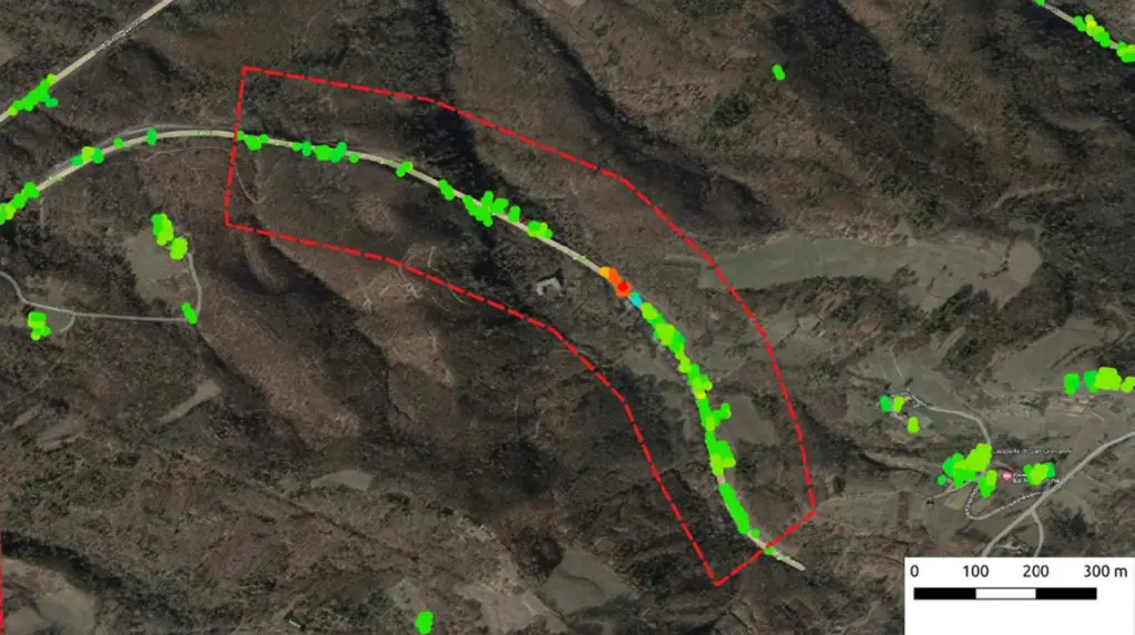
The application of A-DInSAR analysis techniques to Sentinel-1 images, acquired in dual orbital geometry (ascending and descending), enabled the quantification of displacement rates for both natural and man-made features within the area of interest for the period October 2014 – December 2022. The analyses produced a dense and well-distributed network of measurement points located along the highway infrastructure as well as the surrounding territory.
This allowed for the identification and mapping of deformative phenomena, both structural and natural. The displacement maps identified multiple sectors within the area of interest (AoI) with significant displacement rates. These sectors were evaluated as interfering or potentially interfering with the highway and were identified as anomalies. Eleven major anomalies were reported. Among the most affected structures, a viaduct showed cumulative average displacements of -50 mm in descending geometry and +20 mm in ascending geometry.
Based on the results from the historical analysis of Sentinel-1 images, areas to be monitored with high-resolution COSMO-SkyMed images (3×3 meters) were identified in collaboration with the client. Using dual orbital geometry (ascending and descending) COSMO-SkyMed satellite images, it was possible to accurately quantify the displacement rates of natural and anthropogenic elements in the area of interest, covering the period from March 2009 to May 2023. The analyses produced a dense and well-distributed network of measurement points, located both along the highway infrastructure and in the surrounding territory.
The displacement maps confirmed and detailed the results obtained with Sentinel-1 data, identifying several sectors within the four areas of interest with significant displacement rates. These sectors were evaluated as interfering or potentially interfering with the highway, enabling the following:
Future activities include annual monitoring over two years of the four areas of interest using COSMO-SkyMed high-resolution images (3×3 meters). Additionally, to obtain measurement points in critical or high-priority areas, especially in zones with a low presence of natural reflectors, the installation of artificial reflectors (corner reflectors) was proposed. These devices enable high-intensity and stable radar signal backscattering, improving the effectiveness of periodic monitoring.
For effective infrastructure monitoring using InSAR techniques, the following recommendations are made:

